
Файл:Ahtna lang.png

Тӹнгӓлтӹш файл (1026 × 1299 пиксел, файлын размержӹ: 302 Кб, MIME-тип: image/png)
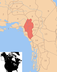
Pre-contact distribution of Ahtna speakers
Резюме
This map shows the distribution of Ahtna speakers before European-contact.
- Present-day country and state boundaries are provided for reference (with broken gray dashes).
- The two rivers that cross Ahtna territory are Susitna (the northernmost river) and Copper (the more southern river). The Yukon and Kuskokwim rivers are also shown for reference.
Neighboring peoples are delineated with brown boundaries and are identified by number as follows:
- Pacific Yupik
- Central Alaskan Yupik
- Deg Xinag
- Denaʼina
- Upper Kuskokwim
- Holikachuk
- Koyukon
- Tanana (a.k.a. Lower Tanana, Minto)
- Gwichʼin
- Hän
- Tanacross (a.k.a. Nabesna, Transitional Tanana)
- Upper Tanana (a.k.a. Nabesna)
- Northern Tutchone
- Southern Tutchone
- Eyak
- Tlingit
- Tagish
- Tahltan
Sources
- Goddard, Ives. (1996). Native languages and language families of North America [Map]. In I. Goddard (Ed.), Handbook of North American Indians: Languages (Vol. 17). (W. C. Sturtevant, General Ed.) Washington, D. C.: Smithsonian Institution. ISBN 0-1604-8774-9.
- Goddard, Ives. (1999). Native languages and language families of North America (rev. and enlarged ed. with additions and corrections). [Map]. Lincoln, NE: University of Nebraska Press (Smithsonian Institute). (Updated version of the map in Goddard 1996). ISBN 0-8032-9271-6.
Лицензировани

|
Ти документӹм Ирӹкӓн программный обеспеченин фондшын 1.2 верси ӓли хоть-махань пӹтӓртӹш верси,
"'GNU Free Documentation License"' лицензи доно копим ӹштӓш, шӓрӹкӓлӓш дӓ/ӓли вашталташ лиэш; вашталтдымы раздел, анзыл монгырыштышы дӓ пӹтӓртӹш монгырыштышы текст гӹц пасна. Лицензин копижӹм GNU Free Documentation License лӹмӓн разделӹш пыртымы. |
| Ти файлым Creative Commons Attribution-Share Alike 3.0 Unported лицензи доно нӓлӓш лиэш. | ||
| ||
| Этот признак лицензирования был добавлен к этому файлу как часть обновления лицензии GFDL. |
- Тӹнь ирӹкӹн кердӓт:
- шӓрӹкӓлӓш – Ти пӓшӓм копим ӹштӓш, шӓрӹкӓлӓш дӓ пуэн колташ
- вашталтен угӹц ӹштӓш – ти пӓшӓм угӹц ӹштӓш
- Техень условивлӓм шоктымыкы:
- атрибуци – Тӹнь яралеш толшы ӓклӹмӓшӹм, лицензилӓн ссылкым пушашлык дӓ вашталтмашым пыртымы ӓли уке манын пӓлдӓрӹшӓшлык ылат. Тидӹм хоть-махань шотан йӧн доно ӹштен кердӓт, но лицензиар тӹньӹм ӓли ти произведеним кычылтметӹм ярыктышашлык агыл.
- ик семӹнь пайылаш – Тӹнь ремиксӹм ӹштет, материалым вашталтет ӓли виӓнгдет гӹнь, ӹшке материалвлӓэтӹм ганьок ӓли оригинал доно икань лицензим кычылтын, шӓркӓлӹшӓшлык ылат.
derivative works
Производные работы от этого файла: Eyak lang.png
en:Ahtna language de:Ahtna (Sprache) fi:Ahtna fr:Ahtna gl:Ahtna hr:Ahtena ja:アトナ
Файлын историжӹ
Файл тӹ жепӹн махань ылын, тидӹм ужаш манын датым темдӓл.
| Дата/жеп | Миниатюра | Висӹк | Пользователь | Комментари | |
|---|---|---|---|---|---|
| кӹзӹтшӹ | 20:14, 21 ноябрь 2006 | | 1026 × 1299 (302 Кб) | Ish ishwar | |
| 19:21, 21 ноябрь 2006 |  | 1026 × 1299 (254 Кб) | Ish ishwar | ||
| 10:52, 13 ноябрь 2006 |  | 1026 × 1299 (267 Кб) | Ish ishwar | ||
| 10:21, 13 ноябрь 2006 |  | 1026 × 1299 (266 Кб) | Ish ishwar |
Файлым кычылтмаш
Ти файлым техень 2 страницӓ кычылтеш:
Файлым цилӓ вӓре кычылтмаш
Ти файл техень викивлӓштӹ кычылталтеш:
- av.wikipedia.org проектӹштӹ кычылтмаш
- bg.wikipedia.org проектӹштӹ кычылтмаш
- ca.wikipedia.org проектӹштӹ кычылтмаш
- de.wikipedia.org проектӹштӹ кычылтмаш
- en.wikipedia.org проектӹштӹ кычылтмаш
- fi.wikipedia.org проектӹштӹ кычылтмаш
- frr.wikipedia.org проектӹштӹ кычылтмаш
- fr.wikipedia.org проектӹштӹ кычылтмаш
- fy.wikipedia.org проектӹштӹ кычылтмаш
- gl.wikipedia.org проектӹштӹ кычылтмаш
- hr.wikipedia.org проектӹштӹ кычылтмаш
- incubator.wikimedia.org проектӹштӹ кычылтмаш
- ja.wikipedia.org проектӹштӹ кычылтмаш
- lez.wikipedia.org проектӹштӹ кычылтмаш
- lt.wikipedia.org проектӹштӹ кычылтмаш
- nl.wikipedia.org проектӹштӹ кычылтмаш
- nn.wikipedia.org проектӹштӹ кычылтмаш
- no.wikipedia.org проектӹштӹ кычылтмаш
- pl.wikipedia.org проектӹштӹ кычылтмаш
- pt.wikipedia.org проектӹштӹ кычылтмаш
- ru.wikipedia.org проектӹштӹ кычылтмаш
- sh.wikipedia.org проектӹштӹ кычылтмаш
- sr.wikipedia.org проектӹштӹ кычылтмаш
- sv.wikipedia.org проектӹштӹ кычылтмаш
- tr.wikipedia.org проектӹштӹ кычылтмаш
Ти файлын кымданрак кычылтмыжым анжал лӓктӓш.